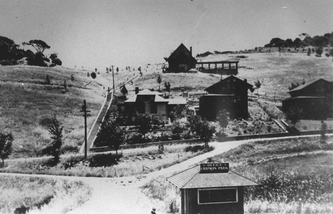
First homes built at Chapman Park, about 1910.
Where Did Our Town Get Its Name?
Most local residents know that “Corte Madera” means “Cut Wood” or “Cord Wood,” and they’ve read or heard that our part of Marin was once part of the Rancho Corte Madera de Presidio, the first land grant awarded by the Mexican Government when it began distributing a total of 21 land grants, beginning in 1834.
But the common belief that our town’s name is derived from ancient redwood trees being cut in Corte Madera to build the Presidio or the city of San Francisco, either before or after the Great Earthquake of 1906, simply isn’t based on fact.
Here’s the real story.
Way, way back in 1776, when Spain established a fortification at the entrance to San Francisco Bay, soldiers were sent out in small boats to gather driftwood, as well as cut branches and small trees, to be used for cooking and heating at the Presidio across the bay. They went to the closest place where that kind of fuel could be found, which was the broad shoreline at the mouth of a stream that flowed into the bay from the southern side of the mountain we know as Tamalpais, over terrain that would later become Mill Valley.
The Spanish soldiers called the place Arroyo Corte Madera, meaning the stream where cord wood is found. That is still its name today, and no, it’s not connected to Corte Madera Creek, which carries the runoff from hills surrounding the Ross Valley into San Pablo Bay, several miles further north. In fact, Corte Madera Creek gained importance as a navigable creek many decades later, when schooners carried passengers and freight to and from Ross Landing, located where College of Marin is today.
In 1821, the Mexican government took over Alta California, and in 1834 a young Irishman named John Reed obtained the first land grant issued by the Mexican government. Reed had been providing ferry service to the Mexican government at the Presidio, shuttling people and goods back and forth across the bay. His 7,845-acre land grant covered most of what we know today as Mill Valley, Tiburon, and Belvedere. Reed chose a site for his home overlooking Arroyo Corte Madera, and his new holdings were recorded as Rancho Corte Madera del Presidio (sometimes shown as Rancho de Corte Madera del Presidio.)
Within a year, Reed had built a sawmill along a different creek nearby, where the flow was strong enough to turn the mill’s water-driven wheel. He operated it for milling lumber from redwood trees for about eight years, until his untimely death in 1843. After that, the mill fell into disuse, and when California came under American rule a few years later, more efficient mills were built at Sausalito and Larkspur, where shipping services were available.
In 1848, the Treaty of Guadalupe Hidalgo ended the Mexican-American War, and the Mexican government turned over all its lands to the United States, which agreed to recognize the validity of Mexican land grants, although each owner had to submit their claim to the U.S. Lands Commission for ratification. The Widow Reed and the four Reed children struggled for nearly 40 years to to get their claim to the Rancho Corte Madera del Presidio validated. It was complicated by several disputed issues that twice caused a review by the U.S. Supreme Court before the Reeds received validation of the full 7,845 acres in 1885.
Their claim to a second Mexican land grant known as the "Tamalpais grant," which had been issued by Governor Figueroa just six days before the end of Mexican rule, was declared invalid by the U.S. Lands Commission in 1854. The land described in the "Tamalpais grant" was then claimed by the United States and became known informally as the Reed Sobrantes or “Leftovers.” It encompassed the western parts of present-day Corte Madera, which were adjacent to the northern boundary of Rancho Corte Madera del Presidio, and extended to Arroyo Holon, the boundary with Rancho Punta de Quentin, near the entrance to today’s Madrone Canyon.
The Reed family fought the U.S. Lands Commission for seventeen years to re-gain title to the “Reed Sobrantes” and they eventually prevailed in 1871. However, the cost of litigation had forced them to sell their claim at deep discounts to land speculators such as William Coleman and Alexander Forbes, who acquired half the land in the "Reed Sobrantes." They leased it for grazing use until near the end of the 19th century, when they subdivided it.
In Marin, the grassy hills surrounding bay tidelands had clusters of oaks, bay laurels, and madrones, but only a few scattered pockets of redwoods, which are usually found in deep canyons with alluvial soil. Such a canyon existed near the eastern base of Mount Tamalpais along Arroyo Holon in present-day Larkspur. In 1849, investors in the Baltimore & Frederick Company of Maryland shipped milling equipment around Cape Horn and set it up at the entrance to what came to be known as Baltimore Canyon, on "Sobrantes" land they leased from the Widow Reed.
The Baltimore & Frederick mill operated 24 hours a day for about a year, clear-cutting all the huge trees and dragging them out of the canyon to the mill with oxen. The milled lumber was hauled out through the tidal sloughs and shipped to San Francisco, where the Gold Rush had created a tremendous demand for construction materials. When all the trees in the canyon had been cut, the crews took off for the gold fields, and the mill was sold and transported to Point San Quentin. Many other mills were set up in various parts of Marin where redwood groves were abundant. But not in Corte Madera, where grassy hills dominated throughout the 19th century, as shown in vintage photographs.
How the name Corte Madera became attached to our locale is a bit of a mystery, but a good guess is that it had a romantic appeal to the families of early settlers such as James McCue, William Eastman, and Frank Morrison Pixley, who were calling it Corte Madera in their writings as early as the mid-1800s. When a two-story building was constructed near the train station around 1890, builder Jerry Adams registered the post office as “Adams, California.” But Morrison I. Pixley soon launched a successful campaign to restore the name “Corte Madera.”
It’s interesting that the town to our south is named Mill Valley for a mill that was in operation for only a few years, and that the town to our north is named Larkspur for a flower that doesn’t exist there, and that our town’s name is translated as Cut Wood, even though there were few large trees to be cut here.
Two little footnotes:
In 1874, Frank Morrison Pixley and his wife paid $2,000 in gold coin to obtain clear title to the 160-acre portion of the “Reed Sobrantes” that his father-in-law, Captain John von Reynegom, had claimed as a homestead in 1860, as well as an additional 30 acres. They called it Owl’s Wood. It includes what we know as Christmas Tree Hill.
When Edgar Chapman developed some of Corte Madera’s grassy hillsides as Chapman Park in the early 1900s, creating “villa home sites for people of quality,” he had 500 trees imported from all over the world for planting alongside the roadways and pathways. Photos showing the grassy hillsides of Chapman Park in 1900 bear no similarity at all to the heavily forested hillsides of Chapman Park today.